DYNAMIC2D
- A fast and easy to use software package for
2D flow simulations
WHAT IS DYNAMIC2D?
CBMC Group has developed its own efficient software package for 2D hydrodynamic flow modelling that allows you to simulate water flows accurately and fast.
Being a general software package, Dynamic2D is applicable to describe the dynamic behaviour of seas, coastal areas, rivers as well as inland flooding due to cloud bursts. Mathematically Dynamic2D solves the mass and momentum equations in two-dimensions (the so-called Saint Venant equations) using an Alternating Directions Implicit (ADI) technique discretised on a uniform, rectangular grid (the Arakawa C-grid).
Dynamic2D includes standard features like:
- atmospheric forcing (wind and air pressure),
- precipitation, evaporation, and infiltration,
- sources and sinks,
- hydraulic structures like culverts, bridges, underpasses, weirs and pumps,
- standard open boundary variations, and
- two-way coupling to drainage systems.
All features may vary in time and space during the simulation. The standard output is time series of water depths and flow vectors in each grid cell of the model domain as well as maps on statistical information like maximum inundation and flow.
Dynamic2D has been designed to make the modelling process seamless and easy. Thus, the model set-up has been automated to the extent possible using available public domain data.
Dynamic2D offers reliable and detailed flow description and statistics at affordable costs.
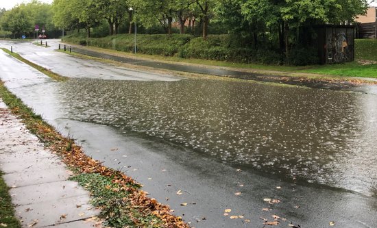
MODELLING OF CLOUD BURSTS
Dynamic2D is especially well suited for modelling of extreme rainfall events over smaller as well as larger areas with the objective to obtain the maximum inundation statistics. The typical information that is needed to produce such maps is data on:
- the terrain model,
- buildings,
- bridges and underpasses such as culverts and alike,
- observed or synthetic time series of the rainfall events,
- land use and infiltration rates, and
- drainage system.
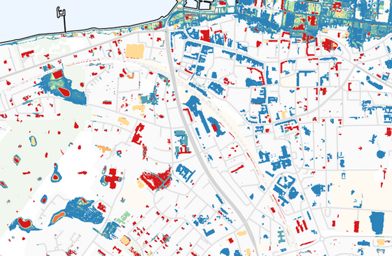
RISK MAP ASSESSMENTS
While risk maps constitute the end goal of most flood analyses the basis for creating risk maps is reliable and detailed flood maps. Flood inundation statistics from Dynamic2D are especially suitable for such analyses and are provided as standard output from Dynamic2D, and ready to be used in for instance UCAT - or any other similar risk assessment package.
To establish a reliable risk map it it typically required to have a minimum of 5 flood maps covering different return periods.
Dynamic2D is the right tool to create the indispensible statistics for coastal and riverine flooding as well as flooding due to cloud bursts.
CLIMATE CHANGE PLANNING AND ADAPTATION
Risk maps form the ultimate basis for climate adaptation planning and mitigation.
While Dynamic2D not only provides the necessary flood maps, it may easily also be used to address 'what if' scenarios to assist in the climate change planning process and to identify the most optimal mitigation measures under consideration.
Thereby Dynamic2D becomes an indispensible tool in the planning and adaptation process.
WHY USE DYNAMIC2D?
It is a well-documented fact that reliable flood maps require the use of dynamic 2D flow models. Dynamic2D is specifically developed to facilitate a fast and easy set-up taking advantage of public domain data sets through a series of semi-automated processes that include:
- automated download of input data sets,
- automated model set-up, and
- automated embedding of bridges and underpasses like culverts and alike
Furthermore, Dynamic2D supports the most commonly used data formats which allow you to use the output directly in other tools.
For more information on Dynamic2D please click here.

FIND US
Birkebakken 80, DK-3460 Birkerød, Denmark
Telephone: +45 2211 1080
Email: info@cbmcgroup.com
CVR: DK40285652
QUICK LINKS
HOME | ABOUT US | DIGITAL CHECK |
MANAGEMENT CONSULTING & ADVISORY |
PROJECTS & PROJECT MANAGEMENT |
Copyright © CBMC Group. All Rights Reserved